


 24/7 Emergency Service
Winter Storm Watch, Advisory and Warning- What's the Difference?
11/30/2018 (Permalink)
 Know the difference between a Winter Storm Watch, Advisory and Warning to Keep Your Family Safe This Winter!
We have entered that time of year in Connecticut when the weather channels will start to warn us that there is a Winter Storm Watch, Warning or Advisory. Rarely will a week go by without one of these warnings in Connecticut. If you've wondered what the difference is between the three, here you go!
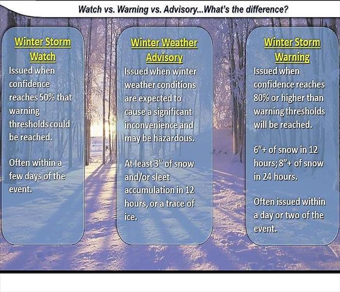
A WINTER STORM WATCH is the first level of warning. It signifies that conditions are favorable to produce winter weather: snow, sleet, freezing rain, icy roads and the like. These conditions may or may not occur, but the weather service is alerting residents to the possibility. In Connecticut, heavy snow means 7 inches or more of accumulation in 24 hours or less. A winter storm watch is a long range prediction. They are issued at least 12 hours before the hazardous winter weather is expected to begin. When the storm becomes imminent, or has a high probability of occurring, the watch will be upgraded to a "WARNING".
A WINTER WEATHER ADVISORY is the second level of warning - a middle man between the watch and warning. It is issued when winter weather is likely to create a hazard. Generally, the weather service is expecting snow, sleet, freezing rain, icy roads and other dangerous conditions. You may see a specific Wind Advisory or a Freezing Rain Advisory issued when these conditions are likely to be coming our way.
A WINTER STORM WARNING means that a winter storm is either expected soon or already taking place. Heavy snow, white-out blizzards, sleet, high winds and significant ice accumulations may be imminent, and residents should prepare immediately for deteriorating conditions. This is issued when a dangerous combination of heavy snow, with sleet and/or freezing rain, will occur or has a high probability of occurring within the next 12 hours.
And in the Torrington area, we're bound to see a BLIZZARD WARNING a few times over the season.This is issued for a combination of strong winds averaging or frequently gusting to, or above, 35 miles an hour and very low visibility due to blowing or falling snow. These are the most dangerous winter storms and can be especially severe when combined with temperatures below 10 degrees.
Of course, as we all know in Litchfield County, the weather can change hour by hour so your best course of action is to check updates regularly and prepare for the worst!